Recently while wandering around the net looking for software to display GRIB files I came across a piece of software named OpenCPN that not only does GRIB files but is also a full featured charting application. Best of all it is free. As in FREE. I just happen to be a big fan of free, so I have spent a number of hours digging into this OpenCPN and I must say I am excited about the possibilities here. The charting software is multi-platform, so currently I have it running on my Ubuntu computer system at home as I try to prepare for the upcoming sailing season. As I said, it is available for other platforms. Windows, Fedora 32 bit, Fedora 64 bit, and my favorite Ubuntu 32 and 64 bit systems. The folks running OpenCPN are currently looking for a Mac OSX developer / package maintainer so perhaps one will be available soon for fans of Macintosh. The current release at the time I’m writing this is 2.3.1.
OpenCPN can use either raster or vector charts which are available for coastal areas and the Great Lakes from NOAA Office of Coast Survey. Also for river systems, the Army Geospatial Center has available for down loading, vector charts for waters under it’s jurisdiction. This is the one I am currently most interested in as we are sailing on Lake Pepin, which of course, is actually the Mississippi River. Once you have your charts installed you can do a host of things, one being, overlaying a GRIB file over the top so you can check wind and barometer forecasts from NOAA as well. Grib.us is where I have got my feet wet with GRIB’s thus far.
For basic, on the water use of OpenCPN, all you need is a lap top computer running one of the aforementioned operating systems and an inexpensive USB GPS which are available every where for little money. Just Google USB GPS. With just this set up in mind, we are excited about trying the anchor alarm feature in particular. Last summer we had the interesting experience of dragging anchor towards a lee shore in the dead of night during an electrical storm and gale force winds and driving rain. We didn’t realize that our anchor had lost it’s grip until daylight arrived and we found our new location much closer to shore than we liked. We learned some valuable lessons to be sure that night. One of which is to check the boats heading to see if it’s 180 degrees off of what it was earlier. The anchor watch feature will add another layer of protection to our slumberings, we hope.
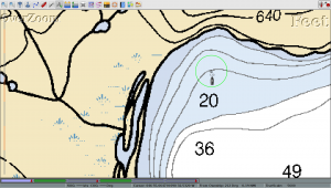
Here is how it works in a nut shell. This is just meant to whet your appetite for more, so to speak, and is not meant as a treatise on the subject. As you can see in the image, we have dropped the anchor and set a perimeter of 120 feet around the boat for swing room, the length you set will be determined by your situation at the time of course. Now if the boat strays outside of this circle, an alarm will be tripped, which consists of an audible alarm and a visual alarm. The program uses ship’s bells for it’s audible alarms, a nice touch I think.
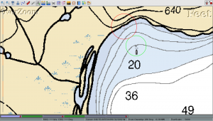
This program also has the capability to monitor two different alarm settings at the same time, which you can see below. Say you are concerned about getting too near the shoreline as we were that night last summer. Then it is a simple procedure to set up another zone for OpenCPN to watch. With this alarm you enter a negative number, so that if your boat strays to within that distance of the mark, the alarm is again tripped.
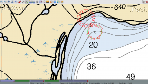
Here is the image to show what the alarm looks like graphically. Here, our boat has drifted too near the shoreline and tripped the alarms. We are awoken from our slumber by the ship’s bells and can take the necessary measures to avoid further problems. Whew!
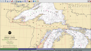
Just one more image for now, to show the big picture using a raster chart downloaded from NOAA the other day. I downloaded the entire suite of Great Lakes charts from NOAA which allows OpenCPN to seamlessly zoom in to all the various chart scales.
I can’t wait till spring when we can put OpenCPN through the paces out on the open water.


